Now, Google has updated Timelapse with the four past years of imagery — it now spans the period from 1984 to 2016 — and "petabytes" of new data, which includes new, sharper images.
The imagery gives you quite an amazing view into various processes that change the shape of our planet — deforestation, glacial motion, urbanization, war. Google offers a curated selection of interesting locations and events, such as the reconstruction of the Oakland Bay Bridge in San Francisco or the movement of the Hourihan Glacier in Antarctica.
San Francisco - Oakland Bay Bridge reconstruction
IMAGE: GOOGLE/LANDSAT/COPERNICUS
You can, however, point the map to any location in the world and see how it changed over time (though the imagery might not be of the same quality everywhere).
See a YouTube playlist with all of Google's curated Timelapse examples, below.
Google has shared an interesting insight on how Timelapse was created on its blog — it took three quadrillion pixels and more than 5,000,000 satellite images to do it. Check out the details here.
Technology is changing the way we connect with our family and friends, so it only makes sense that it would also change how we remember them — something Google Street View is facilitating in surprising new ways.
In recent years, more and more users of Street View have been harnessing the power of the service's time shift feature, which allows you to move backward and forward in time to sometimes catch loved ones as they were captured by Google's Street View cameras.
Google's street mapping tool offers images of a wide range of locations dating all the way back to 2007. Because of that, some users are taking nearly decade-long trips back in time and discovering images of deceased members of their families as they were photographed at their addresses.
Mashable's New York office as it looked in 2007, long before the company took up residence in the building.
IMAGE: GOOGLE STREET VIEW
When compared to a photograph of the same address from more current Street View scans, the contrasting images offer a surprisingly stirring bit of nostalgia only possible in our new digital context.
Yes, the faces are, as a rule, blurred, and you'll usually only find someone you know if you know exactly where to look. But equipped with the right address and a sharp eye for detail, Street View turns into a kind of "god view" of the world, exposing moments in time you wouldn't have otherwise seen.
A search on social media services like Twitter and Facebook quickly reveals a number of surprise Street View memories unearthed by users. But some, like Bill Frankel, have mustered up the courage to share their emotional discoveries. Last month, Frankel shared the pain of his brother stumbling upon their father on Street View, just months after his death.
Another user, going by the name "DUCKS_PDX503" on Reddit, shared his story of finding an image of his grandmother added to Street View just prior to her passing.
An image of a Reddit user's grandmother.
IMAGE: GOOGLE STREET VIEW
"What surprised me, was that Google captured one of the last few pictures of my grandma, because she passed away less than a year after that picture was taken," the user wrote. "I thought it was such an uplifting and awesome picture because it showed just how laid back and awesome she was."
But the Google-facilitated reminiscing isn't limited to human connections. A number of users have taken to Street View to surface old images of their beloved pets as well.
I seriously about burst into tears when I saw that they still had my dog on Google street view before he died pic.twitter.com/2TrDVbPJh7
And whether the subject is furry or related by blood, no one is immune to the inadvertent magic of Street View.
While researching the story for more Street View-powered remembrances, I decided to try it out on one of my own deceased relatives. To my surprise, back in 2007 (the year Street View was launched), I found the familiar image of my late grandmother's car in her Florida driveway and, when I moved the time span control to present day, the driveway and the house were devoid of any trace of her time there. I sat and stared at the image, letting the feelings associated with the memory of my time with her there wash over me. And I was grateful for the accidental archive.
That brief dip back in time provided a powerful tableau of two family images — present and past — juxtaposed against Street View's normally utilitarian function, and it's something I won't soon forget.
Hopefully, Google will take note of this increasingly common cultural hacking of its mapping service by its users and find a way to make these digital ghosts live on, impervious to software updates and database refreshes. In a perfect Street View world, everyone gets to live forever.
{It had been|It absolutely was} probably the most {fascinating|thrilling|interesting} bit of Apple {information|reports|media} that Apple didn't brass at its WWDC keynote Monday: As of the launch of iOS {12|twelve|15} this fall, you will finally be able to delete {the majority of|almost all of} {you can actually|you’re able to send} predetermined {applications|programs|software} from your i phone.
In theory, that's nice thing about it for anyone who has {ever before|at any time} gathered {applications|programs|software} like {Email|Snail mail|Mailbox}, Maps, Tips, Reminders and Stocks together in a folder called something like "Wish {I possibly could|I really could|I can} delete. {inch|inches|very well} In practice, {nevertheless ,|yet ,} it may make some non-Apple {applications|programs|software} unusable.
AS {MUCH|SIGNIFICANTLY|CONSIDERABLY} AS {WE ALL KNOW|WE REALIZE|WE UNDERSTAND}, THE {JUST|SOLE} PRE-INSTALLED APPS {YOU WILL NOT|YOU MAY NOT|YOU'LL NOT} {END UP BEING|GET|COME TO BE} ABLE TO REMOVE ARE ACTUALLY SAFARI, THE APP {SHOP|RETAIL STORE|RETAIL OUTLET}, FIND IPHONE, MESSAGES, {TELEPHONE|MOBILE PHONE|CELLPHONE}, PHOTOS, SETTINGS, WALLET, {TIME CLOCK|TIME} AND CAMERA.
On the one hand, this is very encouraging news; it seems the company has finally woken up and accepted that millions of iPhone users don't want to remain exclusively inside its walled garden. 2 weeks. reversal from the extra bloatware inserted in iOS 9, and a follow-through {on the|over a} promise {Bernard|Harry|Claire} Cook made last {12 months|yr|season}.
On the other {hands|palm|side}, users deleting Apple's {primary|key|main} {applications|programs|software} may create {head aches|severe headaches} for other {applications|programs|software} that rely on them.
Mashable tested this Monday within an early developer beta version of iOS {12|twelve|15}. Specifically, we wanted to look at what happens if you delete the company's much-maligned (if much-improved) Maps App -- which many other {applications|programs|software} use as their only umschlüsselung service.
For example, the Yelp iOS {application|software|iphone app} utilizes Apple Maps. Yelp {presently|at present|at the moment} {will not|would not} {provide a|give you a|give a} Google Maps option. If you erase the default Maps {application|software|iphone app} in iOS 10 and open Yelp, you get this error message.
Mashable reached out to Yelp for comment. A {someone|prolocutor|agent} declined, telling us it was too early for the company to {speak|discuss} about thoughts on the nuances of iOS {12|twelve|15}.
It isn't just Roadmaps. Other {applications|programs|software} rely on the built-in Mail {application|software|iphone app} to send emails, and the Weather {application|software|iphone app} to find your local weather information. Indeed, this is likely the reason Apple won't let you erase Safari -- because so many third-party {applications|programs|software} count {onto it|into it|upon it} for their {built/in|pre-installed|integrated} browser.
It's {completely|totally} possible that most major {designers|programmers|builders} will have fixed all default app-related problems by the time iOS {12|twelve|15} launches. But as {earlier|prior|past} iOS launches have shown, not every developer {made|has turned} their {application|software|iphone app} ready by launch day.
Will Apple's willingness to cede {power over|control over|charge of} its stock {applications|programs|software} {lead to|bring about|cause} any other bugs? {We're going|We will|Most of us} find out this {fall season|show up|land.
A day after announcing an app design and develop accelerator in India's IT capital Bengaluru, Apple inaugurated a new office in Hyderabad focusing on the development of Maps for Apple products.This is the second major announcement that the company has made as part of CEO Tim Cook's maiden visit to the country
Apple has partnered with RMSI, a company that provides software and development expertise for geo-spatial services, for developing its Maps. The new Apple office is expected to generate 4,000 jobs.
“Apple is focused on making the best products and services in the world and we are thrilled to open this new office in Hyderabad which will focus on Maps development,” said Tim Cook, Apple’s CEO. “The talent here in the local area is incredible and we are looking forward to expanding our relationships and introducing more universities and partners to our platforms as we scale our operations.”
The opening of these two centres in India is part of Apple's new-found emphasis on the Indian market. Apple said it supports 640,000 developer jobs related to iOS across India.
“We are honored Apple chose Hyderabad as a home for its Maps development office,” Telangana Chief Minister Kalvakuntla Chandrashekar Rao said. “This will create thousands of jobs here and is a testament to our proactive approach, quality infrastructure and the excellent talent base we have in the region.”
Launched in 2012, Apple Maps has lagged behind Google Maps in features, but recently improved its service by enabling transit support, 3D views and improving its database of place information about restaurants, shops and landmarks from websites like Yelp and TripAdvisor. However, even basic features like navigation are not available on Apple Maps in India, where Google Maps trumps over Apple's offering with its turn-by-turn navigation, live traffic updates, public transport information and offline mode.
The establishment of the office is expected to improve Apple Maps in India.
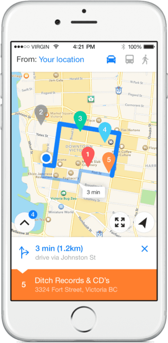
Today’s mapping applications are focused on helping you navigate from one spot to the next, or discovering the businesses around you. But they tend to be utilitarian in nature, and not what anyone would describe as “fun” to use. A new mapping application called Relay changes that. This simple, expertly designed app lets you create custom maps for your upcoming trips, so you can easily visualize in a single map view all the places you plan to visit.
For example, you could add pins to restaurants you want to try, tourist destinations like museums or theaters, stores where you want to shop and even your hotel or Airbnb. By seeing all your pins on the map at the same time, you can get a sense of what’s around you and how far away you are from various locations.
Using Relay is simple, thanks to its thoughtful design.
You can create as many custom maps in the app as you like, and load them up with pins of your favorite places. Plus, you can add notes for each destination to remind yourself why you want to go there, or any other tips you want to remember. Relay also pulls in helpful information to go along with these pins, including a business’s phone number and website address, if applicable.
And with a click of a button, you can rename a pin, mark it as “complete” or get directions. In other words, Relay can function like a traditional mapping application by offering driving, transit and walking directions to your destination.
The app is not a new startup, but rather a side project from Oliver Brooks, a digital product designer based in Canada. His day job is a Design Lead at MetaLab, a full stack design agency in Victoria, which works with clients like Slack, Coinbase, TED, Brit + Co. and others.
This is Brooks’ first foray into mobile apps, he says, though he’s done some freelance work in the past. He designed Relay and worked with a developer he met through a friend, Craig Merchant, to code it.
Brooks explains the idea for the app came from his own experience traveling and a problem he wanted to solve for himself.
“I was really frustrated that you couldn’t do this kind of thing very well with Google Maps or Apple Maps. So, I felt like I might as well try to do something myself,” he says. “I just wanted to make a tool that’s really helpful and easy to use.”
Brooks worked on this bootstrapped project during nights and weekends here and there over the past two years (!!!), and says it feels really good to finally have it done.
Except projects like this are never really done, as it turns out.
An update arriving in a few weeks will let users customize their pins’ color instead of defaulting to Apple Maps’ color scheme determined by business category. The sharing feature will also be improved. Right now it emails a custom file attachment, but the upcoming version will deep link to the custom map right in the app, or point to the App Store page for those who don’t have Relay installed.
Relay is $1.99 on the iTunes App Store. (Side note: It has already moved into a prominent position on my iPhone’s second screen thanks to my upcoming trip to NYC for TechCrunch Disrupt.)
Oh, and by the way, Brooks says he likes making videos, too:




 Popular
 Tags
Tags Videos